E-Flora BC: Electronic Atlas of the Flora of British Columbia

Tanacetum bipinnatum (L.) Sch. Bip.
Floccose Tansy (dune tansy; Lake Huron tansy)
Asteraceae (Aster family)

Introduction to Vascular Plants

© Dave Ingram  Email the photographer   (Photo ID #17206)

E-Flora BC Static Map
Distribution of Tanacetum bipinnatum
Click here to view our interactive map and legend
Details about map content are available here
Click on the map dots to view record details.

SUBTAXA PRESENT IN BC
Tanacetum bipinnatum ssp. huronense

Species Information

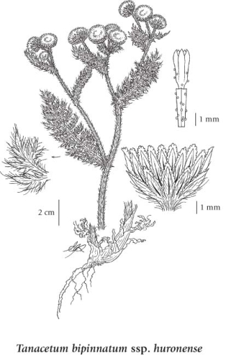
Click on the image below to view an expanded illustration for this species.


General:
Perennial herb from a branched creeping rhizome; stems stout, erect or ascending, several, branched, moderately or more usually long-hairy with flattened hairs, sometimes reddish, 20-60 cm tall.
Leaves:
Basal leaves well-developed and larger than the stem leaves or reduced or lacking, rather thick with an expanded, clasping base, 2-3 times pinnately cut, the ultimate segments with indistinctly winged axis of the inflorescence and blunt or rounded tips; stem leaves similar, smaller, alternate, 5-20 cm long, 2-5 cm wide.
Flowers:
Heads with ray and disk flowers, several, terminal on the branches in a short, flat-topped inflorescence; involucres 4-6 mm tall; involucral bracts lanceolate to oblong, firm except for the papery margins and tip; ray flowers yellow, few; disk flowers yellow, 5-toothed, glandular.
Fruits:
Achenes squared off at the top, 5-angled, ribbed, glandular-dotted; pappus a minute, somewhat lobed crown.

Source: The Illustrated Flora of British Columbia

Habitat / Range

Moist to mesic sand dunes in the lowland zone; infrequent in coastal BC; S to N CA.

Source: The Illustrated Flora of British Columbia

Ecology

Ecological Framework for Tanacetum bipinnatum

The table below shows the species-specific information calculated from
original data (BEC database) provided by the BC Ministry of Forests and Range.
(Updated August, 2013)

Site Information
Value / Class

Minimum

Average

Maximum

Elevation (metres) 0 8 15
Slope Gradient (%) 0 2 9
Aspect (degrees)
[0 - N; 90 - E; 180 - S; 270 - W]
270 275 280
Soil Moisture Regime (SMR)
[0 - very xeric; 4 - mesic;
8 - hydric]
1 1 2
Modal Nutrient Regime
Class
A
Number of field plots
 species was recorded in:
8
Modal BEC Zone Class
CWH
All BEC Zones (# of stations/zone) species was recorded in: CWH(8)

Taxonomic and Nomenclatural Links

Additional Photo Sources

General References